
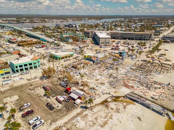
A fast-forming nor’easter shoved the Atlantic straight into East Coast streets while governors moved to brace the line of fire.
At a Glance
- Governors in New York and New Jersey declared states of emergency as the storm hit.
- Forecasts warned of strong winds, coastal flooding, and dangerous surf from the Carolinas to New England.
- Roads in shore towns flooded, and outages rippled across multiple states.
- Travel disruptions and event cancellations followed as conditions worsened.
States Pulled Emergency Levers Early
New York and New Jersey leaders declared states of emergency ahead of the worst impacts and urged residents to avoid travel and coastal areas. A Federal Emergency Management Agency daily briefing also logged emergency declarations in Maryland, Virginia, and North Carolina during a similar September storm cycle, showing how regional leaders often act fast when tides and wind line up against low-lying towns. The early moves helped stage high-water vehicles, utility crews, and shelter options while tides and wind stacked risk hour by hour.
Declarations gave agencies power to close at-risk roads, manage price gouging, and speed mutual aid. That authority matters most along barrier islands where only one road in or out can fail. Officials flagged the Friday evening to Sunday morning window as the most dangerous. That timing tracked with high tides and onshore winds that push water into bays and back rivers. Coastal police forces warned sightseers to stay off seawalls and piers as spray and debris began to fly.
Forecasts Called The Threat: Wind, Water, Waves
National and local forecasts warned of coastal flooding of one to three feet above high tide, heavy rain bands, and strong winds. Forecasters also highlighted wave heights that would chew at dunes and eat up beach width, with the steepest seas in southern New England. Those hazards formed a classic nor’easter setup: long fetch on northeast winds, slow movement, and repeated high-tide cycles that pile up water with little time to drain. The calls proved useful as tide gauges spiked and marine rescues readied.
News outlets echoed that wind and coastal flooding were the main threats and cited gusts topping 60 miles per hour across exposed capes and headlands. Power crews staged extra teams to handle tree limbs on lines, and ferry operators adjusted or paused runs. Beach towns shifted lifeguards and public works crews to dune hot-spots where gaps often form. The message was simple and sober: avoid flood-prone roads, secure loose items, and expect outages and travel snags.
Street Flooding, Erosion, And Outages Hit First
Water rose onto roads in several shore communities as the nor’easter pressed in. Reporters on the ground showed flooded lanes in Ship Bottom and Sea Bright in New Jersey, where bayside surge met ocean push. Ocean City officials warned about beach erosion as pounding surf carved away sand and undercut access points. Power flickered across coastal grids as winds hit, with tens of thousands losing service at points during the peak period. Airlines and rail carriers offered no-fee travel changes to keep people off the roads and platforms.
2 AM Top-of-the-Hour News
Flooded streets. Downed trees and power lines. 150 thousand in the dark from Pennsylvania to Rhode Island. Hundreds of flights cancelled. Thousands more delayed. A powerful Nor-Easter slamming coastal areas from New Jersey to New England. New York… pic.twitter.com/yQGGcdEImV
— Worldwide News Network (@WorldwideNNX) September 27, 2026
Transportation agencies stacked barricades where tides commonly breach, and police closed sections of coastal highways in step with water levels. Public works deployed loaders to move sand back from sidewalks after overwash events. Emergency managers reminded residents that even a foot or two above high tide can trap cars and block ambulances. Many churches and civic centers stood by as warming and charging stations in case long outages set in overnight when crews often pause for safety.
How To Read A Nor’easter Like This One
Nor’easters bite hardest where wind lines up with shallow bays and back bays that trap water. The risk grows when the storm stalls or crawls, because each tide cycle stacks more water over the last. Forecasts that flag surge, wave period, and wind direction help predict which towns take the worst hit. That is why governors and mayors often act before the first flooded street. Fast action protects property and life when minutes matter more than models. NOAA explains that detailed damage surveys come after weather clears, which is why early reports lean on warnings and visuals rather than full tallies.
Common sense says treat saltwater like fire: it ruins what it touches and moves fast when pushed. Homeowners on the coast should park on higher ground, clear drains, and keep power banks charged. Drivers should turn around when water covers a lane, even if it looks shallow. Local leaders who closed roads and staged rescues followed a playbook built on repeated storms. That readiness reflects conservative priorities too: protect families first, secure infrastructure, and keep commerce moving as soon as the water falls.
Sources:
facebook.com, fmcsa.dot.gov, abcnews.com, weather.gov
© totalconservative.com 2026. All rights reserved.